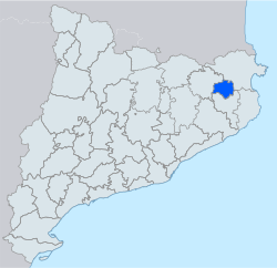
Pla de l'Estany
Appearance
Pla de l'Estany | |
|---|---|
 | |
| Country | |
| Autonomous community | |
| Region | Comarques Gironines |
| Province | Girona |
| Capital | Banyoles |
| Municipalities | |
| Government | |
| • Body | Pla de l'Estany Comarcal Council |
| • President | Francesc Castañer (IdP-ERC) |
| Area | |
| • Total | 262.8 km2 (101.5 sq mi) |
| Population (2014) | |
| • Total | 31,554 |
| • Density | 120/km2 (310/sq mi) |
| Demonym | |
| Time zone | UTC+1 (CET) |
| • Summer (DST) | UTC+2 (CEST) |
| Largest municipality | Banyoles |
Pla de l'Estany (Catalan pronunciation: [ˈpla ðə ləsˈtaɲ]) is a comarca (county) in the Girona region in Catalonia, Spain. Its name means "plain of the lake", the lake in question being the Lake of Banyoles. Banyoles is also the name of the capital of the comarca and home to over half of its people. Pla de l'Estany was established as a separate comarca in 1988 on the basis of a referendum; prior to that it had constituted the northwest part of the comarca of Gironès. The comarca borders the comarques of Garrotxa, Alt Empordà, and Gironès.
Pla de l'Estany is largely agricultural, but has also long had industries in textiles, furniture, leather, iron, and copper.
Municipalities
[edit]| Municipality | Population(2014)[1] | Areakm2[1] |
|---|---|---|
| Banyoles | 19,343 | 11.0 |
| Camós | 686 | 15.7 |
| Cornellà del Terri | 2,235 | 27.7 |
| Crespià | 245 | 11.4 |
| Esponellà | 458 | 16.1 |
| Fontcoberta | 1,442 | 17.3 |
| Palol de Revardit | 474 | 18.0 |
| Porqueres | 4,529 | 33.5 |
| Sant Miquel de Campmajor | 232 | 33.2 |
| Serinyà | 1,123 | 17.4 |
| Vilademuls | 787 | 61.5 |
| • Total: 11 | 31,554 | 262.8 |
References
[edit]- ^ a b "El municipi en xifres". Institut d'Estadística de Catalunya. Retrieved May 25, 2015.
