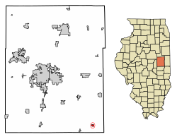
Broadlands, Illinois
Broadlands | |
|---|---|
 Location of Broadlands in Champaign County, Illinois. | |
 Location of Illinois in the United States | |
| Coordinates: 39°54′32″N 87°59′57″W / 39.90889°N 87.99917°W[1] | |
| Country | United States |
| State | Illinois |
| County | Champaign |
| Township | Ayers |
| Government | |
| • Village president | Bruce Block[2] |
| Area | |
| • Total | 0.32 sq mi (0.84 km2) |
| • Land | 0.32 sq mi (0.84 km2) |
| • Water | 0.00 sq mi (0.00 km2) |
| Elevation | 682 ft (208 m) |
| Population (2020) | |
| • Total | 316 |
| • Density | 981.37/sq mi (378.36/km2) |
| Time zone | UTC-6 (CST) |
| • Summer (DST) | UTC-5 (CDT) |
| Area code | 217 |
| FIPS code | 17-08420 |
| GNIS feature ID | 2397459[1] |
Broadlands is a village in Champaign County, Illinois, along the East Branch of the Embarras River. The population was 316 at the 2020 census. Originally owned by the Sullivant family, Broadlands was, at over 70,000 acres (280 km2), one of the world's largest farms in the late 1860s. Broadlands was sold to John T. Alexander in 1866, and it was broken up upon his death in 1876 to pay his creditors.[4]
Geography
[edit]According to the 2021 census gazetteer files, Broadlands has a total area of 0.32 square miles (0.83 km2), all land.[5]
Demographics
[edit]| Census | Pop. | Note | %± |
|---|---|---|---|
| 1910 | 480 | — | |
| 1920 | 384 | −20.0% | |
| 1930 | 377 | −1.8% | |
| 1940 | 361 | −4.2% | |
| 1950 | 333 | −7.8% | |
| 1960 | 344 | 3.3% | |
| 1970 | 315 | −8.4% | |
| 1980 | 346 | 9.8% | |
| 1990 | 340 | −1.7% | |
| 2000 | 312 | −8.2% | |
| 2010 | 349 | 11.9% | |
| 2020 | 316 | −9.5% | |
| U.S. Decennial Census[6] | |||
As of the 2020 census[7] there were 316 people, 122 households, and 88 families residing in the village. The population density was 981.37 inhabitants per square mile (378.91/km2). There were 144 housing units at an average density of 447.20 per square mile (172.66/km2). The racial makeup of the village was 93.67% White, 0.95% African American, 0.95% from other races, and 4.43% from two or more races. Hispanic or Latino of any race were 2.53% of the population.
There were 122 households, out of which 28.7% had children under the age of 18 living with them, 67.21% were married couples living together, 3.28% had a female householder with no husband present, and 27.87% were non-families. 19.67% of all households were made up of individuals, and 11.48% had someone living alone who was 65 years of age or older. The average household size was 3.32 and the average family size was 2.79.
The village's age distribution consisted of 22.9% under the age of 18, 9.7% from 18 to 24, 22.3% from 25 to 44, 27.9% from 45 to 64, and 17.1% who were 65 years of age or older. The median age was 40.0 years. For every 100 females, there were 94.3 males. For every 100 females age 18 and over, there were 89.9 males.
The median income for a household in the village was $53,500, and the median income for a family was $76,875. Males had a median income of $45,417 versus $21,500 for females. The per capita income for the village was $22,762. About 20.5% of families and 20.9% of the population were below the poverty line, including 11.5% of those under age 18 and 25.9% of those age 65 or over.
Community
[edit]Water is piped from the Mahomet Aquifer, as compared to the treated well water provided by most other nearby villages.
Elementary and junior high students from Broadlands attend school in Homer, while students in all of Heritage Community School District #8 (Homer, Allerton, Broadlands, Longview) attend the expanded high school in Broadlands.
The Broadlands Community Club holds a homecoming festival each year. The Club typically has events throughout the day for children and adults including a parade, afternoon entertainment, a fish fry and homemade pies.
References
[edit]- ^ a b c U.S. Geological Survey Geographic Names Information System: Broadlands, Illinois
- ^ "Incorporated Cities, Towns & Villages of Illinois" (PDF). Illinois Blue Book (2021-2022 ed.). Springfield. ISSN 0191-104X. OCLC 1645571.
- ^ "2020 U.S. Gazetteer Files". United States Census Bureau. Retrieved March 15, 2022.
- ^ "The Cattle King" (PDF). New York Times. September 3, 1876.
- ^ Bureau, US Census. "Gazetteer Files". Census.gov. Retrieved June 29, 2022.
{{cite web}}:|last=has generic name (help) - ^ "Census of Population and Housing". Census.gov. Retrieved June 4, 2015.
- ^ "Explore Census Data". data.census.gov. Retrieved June 28, 2022.

